

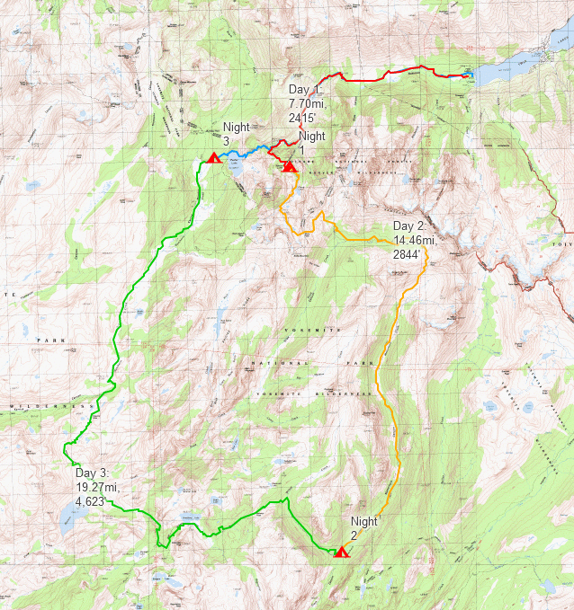
I moved to California last year, and one of the first recommendations I received was a glowing review for this 50 mile backpacking loop in the Sierra. That was November of 2022, I finally got permits and set out on the trail over Labor Day Weekend of 2023. Two friends and I spent a chilly 3 nights and 4 days backpacking through Hoover and Yosemite Wilderness, starting and ending at the Robinson Creek trailhead in Bridgeport, California. Our route covered approximately 50 miles with 10,000 feet of elevation gain and followed a clockwise path, starting at Robinson Lakes to Matterhorn Canyon, past Benson Lake, and then to Peeler Lake.
Permits & Parking
We secured permits through the Humboldt-Toiyabe National Forest system for the Robinson Creek Trailhead. The cost for a 3-night, 3-person permit is $15. Most trailheads in the area operate on a quota system, with half of the permits becoming available 6-months before a start date, and the other half opening up at 7am PST three days before. The first half are almost always sold out during summer months (especially on weekends!), so be ready to purchase the permit right at 7am for the best chance. We purchased our permits 3 days before and had no issue. Permits and more information can be found here: Humboldt-Toiyabe National Forest Permits.
The Robinson Creek Trailhead starts behind Annette’s Mono Village, where a 7-day parking pass costs $15 and can be purchased at the campground’s entrance. While space availability was not a concern during our visit (and it seemed like they had plenty of space), it’s always wise to check in advance.
Route
We started late afternoon on Friday, September 1st 2023. To minimize time off from work, we had left the Bay Area that morning and then had gotten postponed by some landlord issues that meant that we didn’t start our hike until about 4:30pm. The trailhead is located a ways back behind the campground, but is not to hard to locate from the parking area.
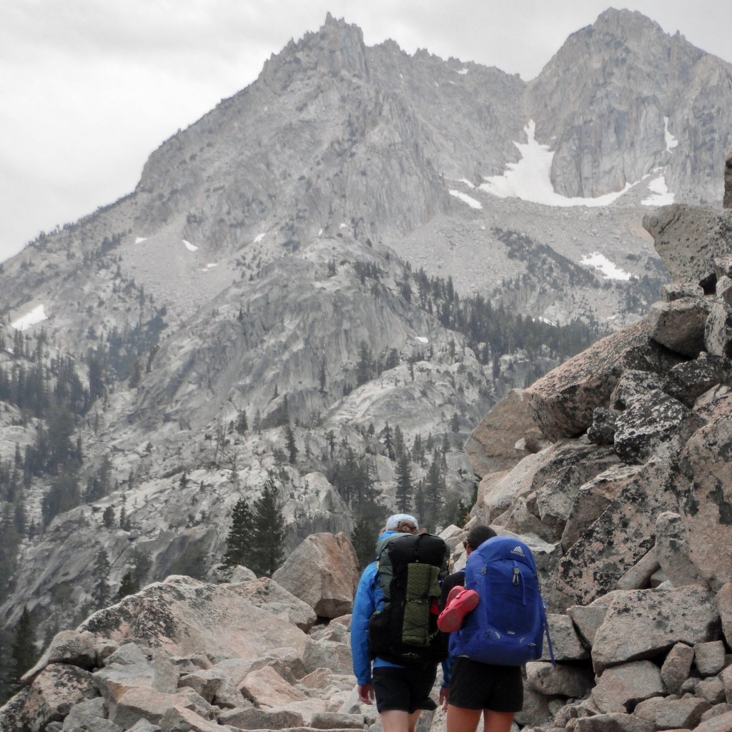
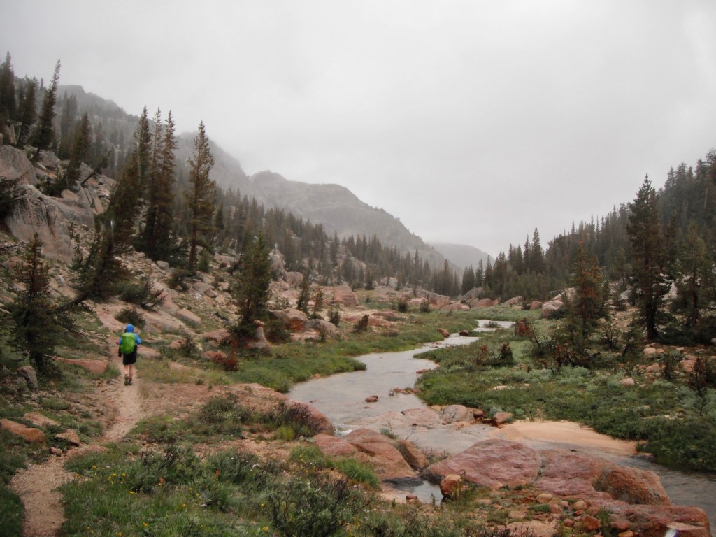
I had made the first day significantly shorter since I knew we would be starting later in the day, and had slept the night before at sea level. The hike in was 7.7 miles with 2,415′ of elevation gain, and went by pretty quickly. Most of the elevation gain occurred during a long set of switch backs and there were some great views to keep you distracted and the trail followed a creek or lake almost the entire way. We thought about camping at Crown Lake, but decided to camp at the south side of the Robinson Lakes chain to reduce our hike by a mile and a couple hundred feet — as the light was already starting to fade. The winds really picked up as the sun set, and camping in the big trees around the lake provided some much-appreciated protection. If it’s not occupied, the tiny lake at the north side of Robinson Lakes is adorable, incredibly blue and would make a great campsite.


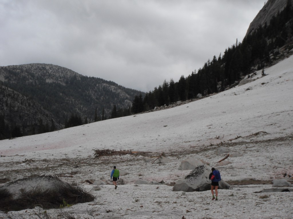
On Saturday, we woke up to chilly temperatures and intermittent rain. We had two passes on the docket today, Mule Pass, then Burro Pass. Worried about possible thunderstorms, we were motivated to get moving and minimize time above tree line. Even in September, the record snow pack was still covering the trail on the majority of Mule Pass. The trail switch backs up a boulder field that was easy enough to navigate between the patches of snow. We did have to do a few snow crossings, but the snow was still firm and stable. As soon as we reached the top of the pass, the sky opened up and it started pouring (above left). The top of Mule pass is the border between Hoover and Yosemite Wilderness, so we got our rain layers on and hiked down into Yosemite. Burro Pass was in similar condition: lots of snow covering the trail leading up to it and a brief little boot pack to get over the top. The moment we crested the pass, the wind coming up Matterhorn canyon smacked us right in the face and continued to howl until we got below tree line. This pass sits right below Matterhorn Peak, but because of the low hanging clouds we only got a few brief glimpses. Alas.

Matterhorn canyon is easy, breezy hiking and we cruised down the trail to end the day at 14 miles and 3000′ elevation gain. The only obstacles we encountered after Burro Pass were massive quantities of snow deposited by an avalanche (above left) and numerous creek crossings. We decided to camp at the base of Benson Pass, the northwest side of where Wilson Creek enters Matterhorn Creek. It felt great to camp at 7000′ after spending much of the day at 10,000′. Our plan was to camp another mile up the trail, where it seemed to flatten out a bit and would take off some of the elevation gain from the morning, but we weren’t sure whether it would be camp-able and didn’t want to risk it. After seeing it the next day, it would’ve been a lovely spot to camp.


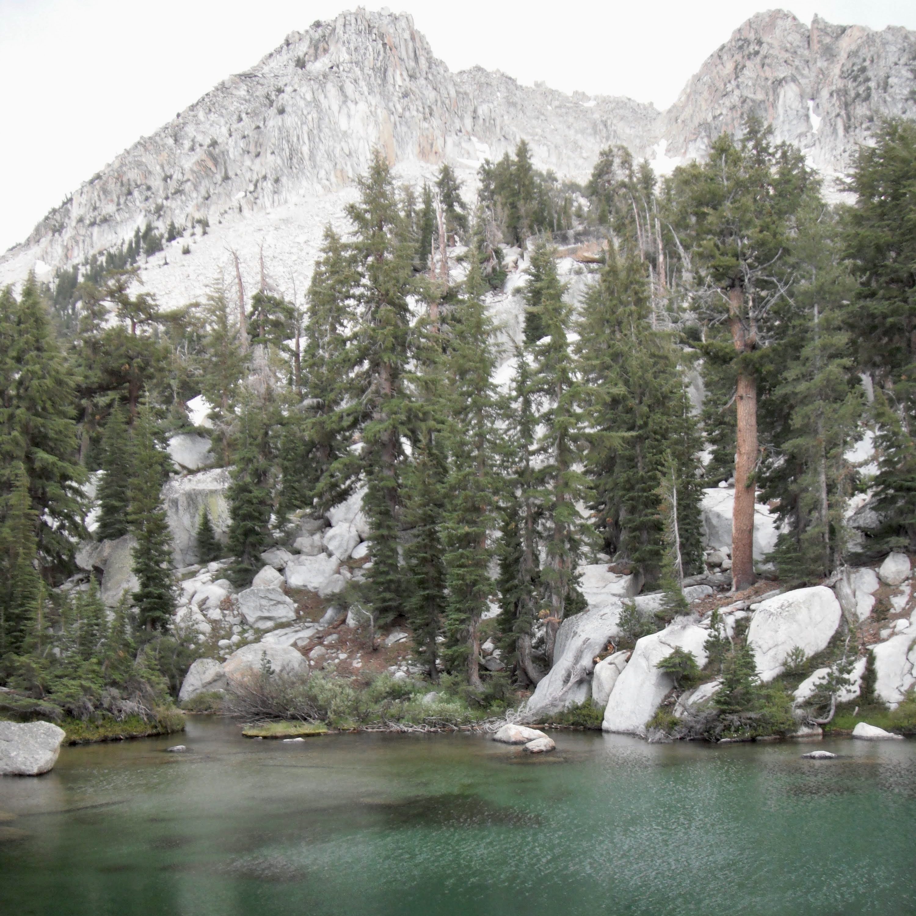
We didn’t plan to hike the 20 miles to Peeler Lake on Sunday, but it didn’t stop raining for 8 hours and nobody wanted to set up a tent in the rain, so we did. Saturday’s weather wasn’t great, but Sunday turned out to be much colder and more consistent rainfall. Both passes of the day, Benson and Seavey, were beautiful and hard. Seavey seemed to last forever, winding up and up into the clouds. Even though we were on the PCT Super Highway, we only saw a few people all day. Some of the main highlights of the day were all of the lakes scattered at the tops of the passes, many of them not marked on my map. The valley below Seavey Pass was like entering a completely different ecosystem. It was all giant meadows with rivers winding through sandy banks and big chunks of granite sticking up into the air.
By mile 16 we were freezing, had no sensation in our fingers, it had begun to hail, and moral was low. The trail through the meadow was flooded from 3 days of rain and we were sloshing through calf high water, so we switched on turbo hiking mode and walked as fast as we could. Eventually the wintery mix subsided a bit and we spotted a place to camp and took that opportunity like our life depended on it. Nothing motivates backpackers quite like trying to get a tent set up in a gap in a storm.


We woke up Monday morning to cold noses and a frozen tent. Actually, everything was frozen, but we could finally see the sky again and our love of backpacking returned. After spending a few hours thawing our items in the sunshine, we cruised down the 8 miles back to the trailhead. Our tuna packets and PB&J lunch no longer sounded appetizing, so we treated ourselves with real food from Annette’s Cafe. It might be the backpacking hunger speaking, but I highly recommend.
Our totals for the trip were 49.93 miles, 10,325 feet of elevation gain, 3 wet sleeping bags, and a deep sense of appreciation for the sun. This route was a sampler pack of what the Sierra has to offer: hiking below lofty granite peaks on a boulder field, low valley filled with desert shrubs, giant sandy meadows, huge trees on the banks of rocky rivers, and I would highly recommend it to anyone looking for a long weekend backpacking trip. Next up, climbing Matterhorn Peak!
Gear
All of the gear I brought on this trip can be found at LighterPack.
Key Players:
- Rainproof mitts were a life safer hiking during the cold, rainy days. Best worn over a pair of wool liners.
- Brought a 20 degree bag and was toasty down to 30 degrees.
- Foam seat pad. So nice to have something dry and soft to sit on, and makes a nice welcome mat to the tent.
Wish I had:
- Rain pants for warmth while hiking in the cold and rain.
- A proper pillow for added comfort (I wore all my layers that I typically use as a pillow).
- A plastic bag for phone protection during wet weather (My phone broke after 12 hours in a wet hip belt pocket).
- An additional warm layer that I would’ve been okay with getting wet.
Nitty Gritty Details
Weather:
| Date | Temperature | Feels Like | Humidity | Wind Speed | Notes |
|---|---|---|---|---|---|
| 9/1/23 | 57°F and windy | 55°F | 31% | 21.4 mph | Strong gusts, some rain |
| 9/2/23 | 44°F and windy | 36°F | 75% | 16.0 mph | Strong gusts, intermittent cold rain |
| 9/3/23 | 40°F and cloudy | 35°F | 79% | 8.3 mph | Cold and rainy, hail and snow in the evening |
| 9/4/23 | 43°F and sunny | 41°F | 52% | 3.2 mph | Below freezing overnight, clear skies in the morning |
Food: it was sufficient, but I wish I would’ve brought more snacks.
| Date | Breakfast | Lunch | Dinner | Dessert |
|---|---|---|---|---|
| 9/1/23 | ——————— | Hummus powder, cheddar cheese, GF tortilla | Rice and curry packets | Oreos + tea |
| 9/2/23 | 1/2 cup protein oats, instant coffee | Tuna packet, cheddar cheese, GF tortilla | Instant mashed potatoes, beans, veggies | Hot chocolate |
| 9/3/23 | 1/2 cup protein oats, instant coffee | Tuna, cheddar cheese, GF tortilla | Macaroni noodles, instant chili, cheese | Candy + Oreos |
| 9/4/23 | 1/2 cup protein oats, instant coffee | Annette’s Mono Village Cafe | ————————— | ————— |
Snacks:
- Various granola bars
- Kirkland chewy protein bar
- Skratch blueberry energy chews
- Dill pickle cashews
- Life saver gummies
- Sweet tart ropes
Hydration:
- Electrolyte fast chews
- Nuun
Disclaimer: Most links are affiliate links, on which I may earn a small commission. Purchasing through them helps to support me and my content! I only recommend products that I have tested, love, and use regularly.
Discover more from Trail Carrot
Subscribe to get the latest posts sent to your email.
